Webinar: “LPV Implementation in Europe: from EGNOS SoL declaration to PBN IR”
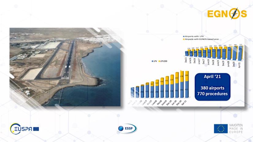
In 2021, we celebrate that EGNOS Safety of Life service has been serving European airports for the past 10 years. Do not miss this webinar if you want to learn how EGNOS implementation has progressed during the last decade, since the first LPV procedure’s publication on March 17th 2011 up to reaching near 800 available today. Details will be provided on the evolution of procedures over time, as well as available STC/SB solutions and operators already equipped to use EGNOS. Additionally, we will show other tools and materials available for free to support all those that are interested to adopt EGNOS this great PBN enabler. Do not miss it!
This webinar is organised by EUROPEAN SATELLITE SERVICE PROVIDER (ESSP) in collaboration with EUROPEAN UNION AGENCY FOR THE SPACE PROGRAMME EUSPA, and it will take place on 16th June. It aims at EGNOS users in civil aviation, from ANSPs, Aircraft Operators, DOAs, avionics manufacturers, and in general, all those interested in the role that EGNOS is playing as an enabler in performance based navigation in Europe. It will provide the latest figures on the implementation of the EGNOS SoL (Safety of Life) service in aviation and it will show the audience its evolution in the last 10 years.
Do you know who can use the EGNOS SoL Service?
This service provides the most stringent level of signal-in-space performance to all Safety of Life user communities. The main objective of the EGNOS SoL service is to support civil aviation operations down to Localizer Performance with Vertical Guidance (LPV) minima. To date, a detailed performance characterisation has been conducted only against the requirements expressed by civil aviation. However, the EGNOS SoL service might also be used in a wide range of other application domains (e.g. maritime, rail, road…) in the future. In order to provide the SoL Service, the EGNOS system has been designed so that the EGNOS Signal-In-Space (SIS) is compliant with the ICAO SARPs for SBAS. The EGNOS SoL Service has been available since 2nd March 2011.
Milestones and practical cases
You will be presented a synopsis of the different milestones that the EGNOS SoL Service has met since March 2011, and the main benefits that this service is offering to civil aviation. Relevant LPV implementation success stories that have taken place over these years will be shown.
Ten years of safer skies with EGNOS
The EGNOS Safety of Life (SoL) Service is provided openly and is accessible free of charge. It is tailored to safety-critical applications, in particular, the service is compliant with the aviation requirements for Approaches with Vertical Guidance (APV-I) and Category I precision approaches, as defined by ICAO. The free of charge available EGNOS service requires no ground equipment whatsoever, replacing the radio guidance beamed upward by traditional CAT I Instrument Landing System (ILS) infrastructure with no decrease in performance.
…To reach 2024
The number of Airports with LPV has doubled in the last years. The so-called PBN IR will further stimulate the implementation of EGNOS based procedures in most of the remaining airports because this Regulation made it mandatory for the Air Navigation Service Providers to publish RNP approaches at all the runway ends without precision approaches before the end of 2020, and at all the rest of runway ends (already with a precision approach) by 2024.
If you want to register to this webinar, please click here.
Event date: 16 Jun 2021
Hours: 15:30 – 16:30 CET
About EGNOS
The European Geostationary Navigation Overlay Service (EGNOS) is Europe's regional satellite-based augmentation system (SBAS). It is used to improve the performance of global navigation satellite systems (GNSS), such as GPS and Galileo in the near future. It has been deployed to provide navigation services to aviationusers over Europe, and it is also available for other transport and market segments such as maritime, rail, agriculture, geomatics and road.
EGNOS uses GNSS measurements taken by accurately located reference stations deployed across Europe. All measured GNSS errors are transferred to a central computing centre, where differential corrections and integrity messages are calculated. These calculations are then broadcast over the covered area using geostationary satellites.
As a result, EGNOS improves the accuracy and reliability of GNSS positioning information, while also providing an integrity message critical for Safety of life applications, as is the case in aviation.
About EGNOS Service Provider (ESSP)
ESSP SAS (European Satellite Services Provider) core activities are the operations and service provision of EGNOS.
ESSP is founded by 7 key European Air Navigation Service Providers: Skyguide, DFS IBS, DSNA, AENA, NATS, ENAV, and NAV.
Next webinars
There will be more webinars during this year, please visit the NEWS page at the EGNOS User Support Website to stay tuned.
